
This section of the coastal path was one of the first section we completed, and now I look back it was a while ago in May 2017. But it hasn’t gone anywhere, it’s still there and remains a great walk. There’s a particular kind of hush that falls over Freshwater West the moment you step off the car park and onto the crest of the dunes: the Atlantic lays out its long, breathing swell, gulls wheel and the sand runs away from your boots in soft ridges. On a bright day it can look almost cinematic — no surprise, then, that filmmakers have loved it — but in truth Freshwater West is most affecting when you remember it is a place of real geology, real danger and real human stories, all layered into a single long bay.

People have made use of this stretch of coast for centuries. The shapeless dunes and sheltered pockets once offered refuges for smuggling and local subsistence; later, the area’s open character and powerful surf made it a magnet for recreation and — more recently — for film crews. Freshwater West featured prominently in Ridley Scott’s Robin Hood and in the Harry Potter and the Deathly Hallows films, where the “Shell Cottage” and Dobby’s grave were filmed on the dunes (the cottage was removed after filming). The Dobby memorial has become a modern pilgrimage spot — and a conservation concern — with the National Trust asking visitors to respect the fragile dune ecology.
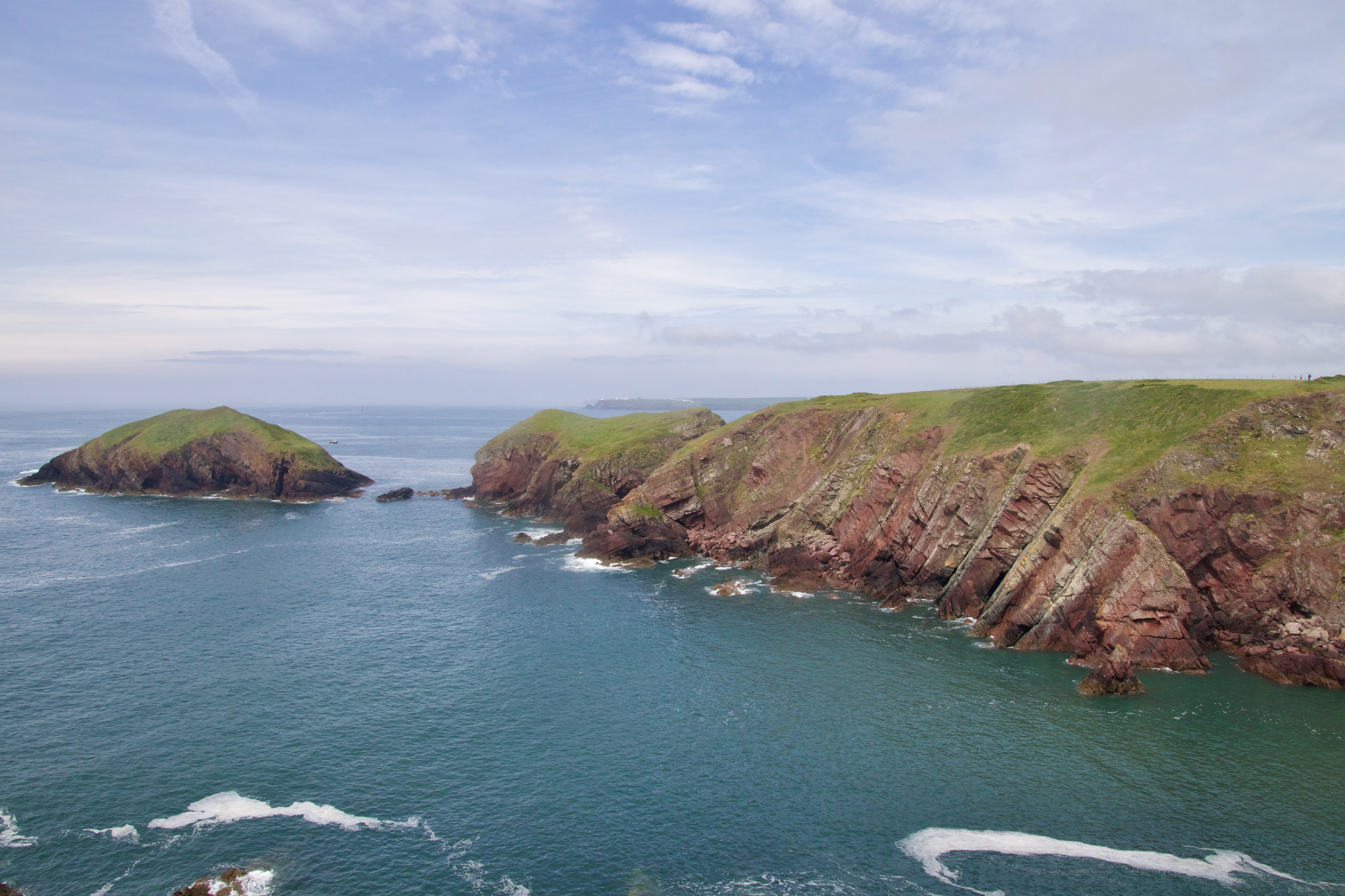
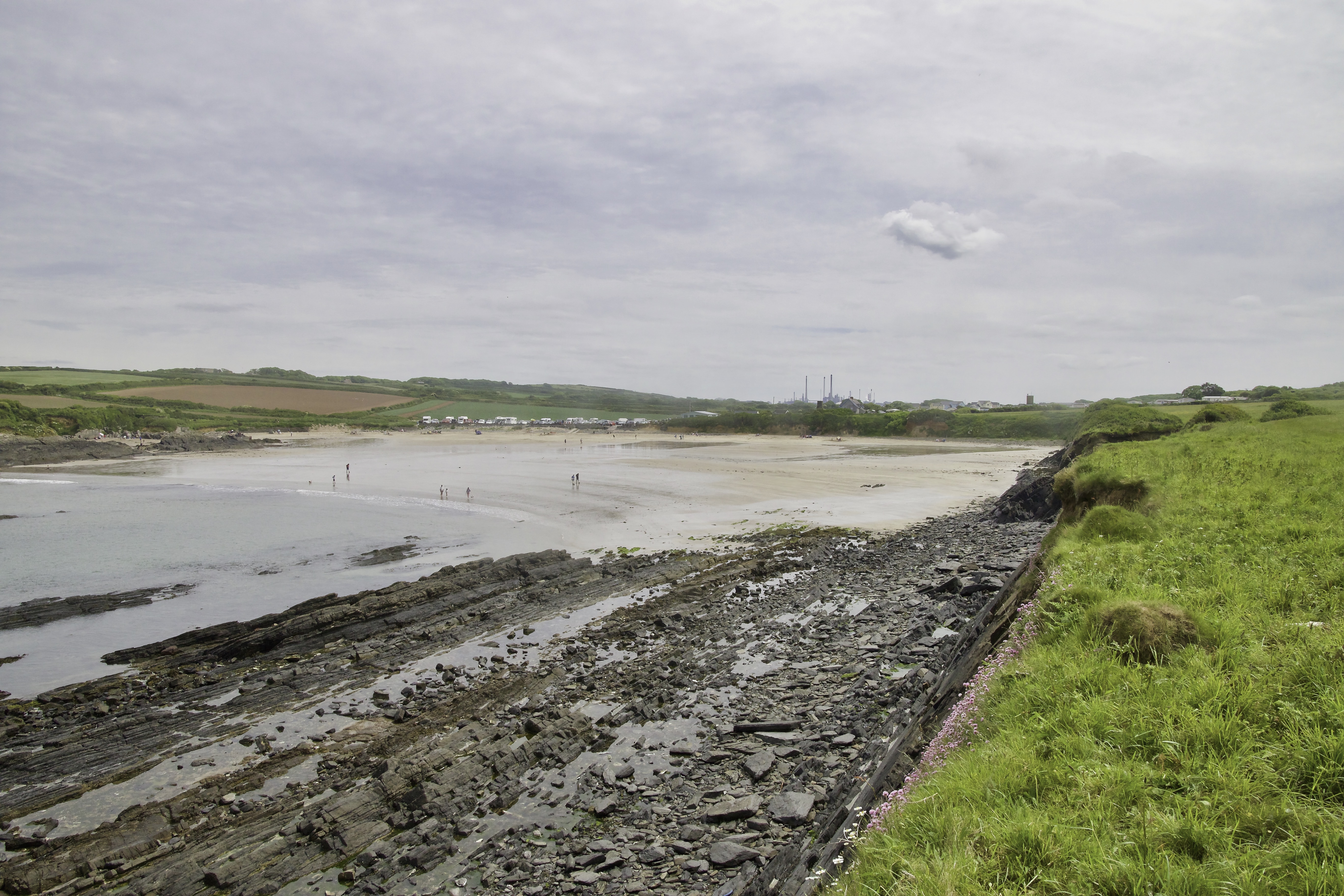
Walk north from the car park and the cliffs and headlands read like a geologist’s map. The headlands around the bay are dominated by Old Red Sandstone and red beds of the Lower Palaeozoic sequence: hard, steep-faced rock that resists erosion and forms jagged cliffs, while the softer mudstones and siltstones have been worn back to create the wide sandy bay and dunes you walk today. Behind the beach lie extensive dune systems — Broomhill Burrows and Gupton Burrows — and, inland from those, marshy fen and pasture that reflect the pocketed valley drainage of this peninsula. Tidal ranges are large here and currents can be powerful; the interplay of rock type, wave energy and tide has produced the long, almost mile-wide sweep of sand that defines Freshwater West.

If the beach feels cinematic now, its history is often tragic. Freshwater West has long claimed ships and stirred headlines. In April 1943 two Landing Craft Gun (LCG 15 and LCG 16) were lost in a violent storm off this stretch; around 85 service personnel died and many bodies washed ashore — there is a local memorial remembering the event and its terrible toll. Earlier still, Victorians recorded the stranding of merchant ships here: one well-known wreck in the nineteenth century spread cargo and debris along the sands and (for a while) became the raw material for local industry and lively salvage stories. Even now, storms sometimes uncover old timbers or the “upside-down wreck” that local writers and visitors recall — a reminder that this lovely bay can be unforgiving.
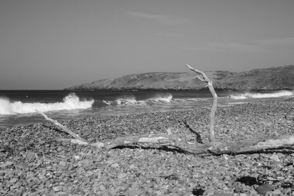
Walking along the path west from Freshwater West a small island starts to become your companion. Sheep Island lies close enough to shore to feel almost reachable, yet far enough away to remain utterly separate. At low tide the channel narrows and the rock platforms show themselves, tempting the unwary; at high tide the Atlantic closes in decisively, cutting the island off and reminding you that this is not a place to misjudge time or weather.
The name is literal and practical. For centuries, small coastal islands like this were used for seasonal grazing, particularly sheep, which could be ferried across or driven over at very low tides. Isolation protected them from predators and theft, while the salt air and short turf suited hardy animals. Whether Sheep Island was regularly grazed or simply named by analogy with similar islands nearby is uncertain, but the tradition is deeply rooted in Pembrokeshire’s coastal economy.
Like so many offshore rocks along this coast, Sheep Island has long been a navigational hazard. Low-lying and difficult to spot in poor visibility, it sits in waters affected by strong currents and swell. While there is no single, famous wreck definitively tied to Sheep Island itself, its presence contributes to the overall danger of the Freshwater West stretch — part of the same maritime landscape that claimed ships driven landward in storms. It was here, in 1854, that the wooden schooner Speedwell met her fate.
Driven onto Sheep Island in heavy weather, the Speedwell did not immediately disintegrate. Instead, she grounded hard on the rock — damaged but not destroyed — and for a short time, it must have seemed possible that she might yet escape. Records suggest she was floated off the island, whether by tide alone or with assistance, and carried back into open water. But the sea had already claimed her. With her hull compromised, the Speedwell sank not far away, settling on the seabed some 300 to 400 metres northwest of Sheep Island, where her remains are now logged as part of the submerged archaeology of the Milford Haven approaches.
There is little drama preserved in the written record: no famous loss of life, no heroic rescue that fixed her story in national memory. And yet that quietness is precisely what makes the Speedwell representative. She was one of many working vessels whose loss barely rippled beyond the local coast — ships that fed trade, carried livelihoods, and vanished with minimal ceremony.

Even today with modern engine driven craft and navigational aids Sheep Island remains a hazard. Late in October 2015, the crabbing boat CKS struck rocks near Sheep Island, tearing a two-metre gash below its port side. With water rushing in, the five crew members were forced to abandon ship, rescued swiftly by the Angle Lifeboat. Over the following days, attempts to salvage the vessel failed, and the CKS sank off West Angle beach, vanishing completely under the high tide. The wreck posed a hazard to local shipping, prompting the Port of Milford Haven and the insurers to call in Braemar Howells, a local salvage specialist. Refloating the vessel was essential, but towing it to Pembroke Dock was too risky. Instead, the decision was made to bring the boat ashore at West Angle, a safer option but one fraught with environmental concern. The beach lies close to a Special Area of Conservation, home to the delicate cushion starfish, Asterina phylactica. Over several tense days, divers secured straps and flotation bags. Finally, on Friday the 6th, the CKS was lifted on the high tide and towed into the shallows, ready for dismantling on the sand.
As we turned the northern edge of the Angle Peninsula Thorn Island came into view. Originally built in 1855, Thorn Island Fort was constructed during the period of the Cardwell Reforms, initiated in 1860. This was a time when Britain’s military saw increased scrutiny and a pressing need to strengthen coastal defences was recognised. Following the Crimean War (1853-1856), the British government faced significant challenges regarding naval security, particularly in vulnerable coastal areas like the Milford Haven Waterway, a key naval base.

The fortification of Thorn Island was a strategic response to threats posed primarily by the French navy, which was perceived as a significant danger during the 19th century. The area surrounding Thorn Island was fortified to protect against potential invasions, reflecting the broader military strategy of the time to bolster Britain’s coastal defenses.
The political climate was marked by internal agitation and reform movements advocating for better military practices, as well as wiser public spending on defense. As soldiers occupied the fort, they served not only as guardians of the shoreline but also as figures representing the tensions of their era—the balance between national security and public sentiment. Over time, as geopolitical dynamics shifted, the fort’s importance diminished, rendering it a relic of a bygone era, rich with stories waiting to be uncovered.
Today Thorn Island is privately owned and the family are offering it private hire events, filming and are hoping to be able to offer day trips in the future. It certainly looks and interesting project, and I really hope they make a success of it. You can see more on their website – https://www.thorneisland.uk/.
Almost opposite Thorn Island we approach a wide open west facing bay. Where Freshwater West opens itself fully to the Atlantic, West Angle Bay turns inward. Just a short distance along the coast path, the character of the sea changes almost imperceptibly. The wide, exposed sweep gives way to a gentler curve of sand and shingle, backed by low cliffs and pasture, and the water lies calmer, more contained. This contrast is not accidental — it is geography at work — and it explains much about how people have used and understood this place for generations.
West Angle Bay sits within the protective arms of the Milford Haven waterway, one of the finest natural harbours in Britain. While storms still reach here, their force is broken, refracted by headlands and islands. For sailors, this difference could mean survival. Seen together, Freshwater West, Sheep Island and West Angle Bay form a kind of coastal conversation. Freshwater West is the warning — wide, exposed, unforgiving. Sheep Island is the hazard — low, deceptive, easily underestimated. West Angle Bay is the answer — not safe, but safer; not calm, but calmer.
The path then follows on around the southern edge of Milford Haven to the small village of Angle. We could have taken a short cut across the isthmus, but that would have been cheating. Where Freshwater West opens itself fully to the Atlantic, West Angle Bay turns inward. Just a short distance along the coast path, the character of the sea changes almost imperceptibly. The wide, exposed sweep gives way to a gentler curve of sand and shingle, backed by low cliffs and pasture, and the water lies calmer, more contained. This contrast is not accidental — it is geography at work — and it explains much about how people have used and understood this place for generations.
Angle’s fortunes have always been tied to the Milford Haven waterway, one of the deepest natural harbours in the world. As shipping increased from the Tudor period onwards, the village found itself on an increasingly busy maritime route.
Angle is best known today for its RNLI lifeboat station, established in the nineteenth century. The station became one of the most active in Wales, responding to incidents across the Haven approaches and the open sea beyond. Generations of Angle families served as lifeboat crew, often launching in appalling conditions. The lifeboat station gave the village a national role: small in size, but vital in function. Acts of bravery carried out by local crews earned medals and quiet respect, reinforcing Angle’s identity as a place that does not turn away from the sea’s dangers.
Today, Angle feels settled, purposeful and slightly removed from the rush elsewhere. Its green, its pub, its church and its lanes all point to a village that has learned how to endure. The pub was not on the agenda this time because we needed to complete the loop back to Freshwater West where the car was parked. So after 10.5 miles we staggered back cross country to the car park at Freshwater West with a real sense of achievement.
Previous section: https://paulchallinor.com/2019/04/28/freshwater-west-to-castlemartin/

Leave a comment