
It’s late March 2023, and it had been almost 4 months since we last went for a walk, winter seemed to be so long this year. A long overdue weekend away drew us to Pontarfynach or Devil’s Bridge. A small village set above a steep and narrow Cwm Rheidol west of Aberystwyth. The Afon Rheidol is 19 miles in length with a catchment area covering 73 square miles. Rising in the headwaters of the Nant y Moch reservoir on the western edge of Plynlimon the fiver flows south through the village of Ponterwyd on the main Aberystwyth to Rhayader road. Continuing south-westwards through ancient Welsh Oak woodlands, the Afon Rheidol joins with the Afon Mynach before descending over one of the most spectacular waterfalls in Wales at Pontarfynach (Devil’s Bridge).

This was an 8 miles circular walk starting and finishing in Pontarfynach, a small village well know in Wales primarily for the legend of a local widow who was having trouble finding enough grazing for her goat. The better pasture was on the opposite side of the steep ravine from where she lived. One day the devil appeared and offered to build a bridge in exchange for the first living thing to cross it. The widow agreed, and the devil built the bridge, anticipating that the valuable goat would be the first to cross. But the widow was worldly wise and not so easily duped, she threw a piece of bread across the bridge and her dog ran after it, becoming the first living thing to cross the bridge. In some stories it was a monk who tricked the Devil which which supposedly give rise to the name Pontarfynach, which translates as “bridge of the Monks” in English. The name is derived from the Welsh words “pont” meaning “bridge,” “ar” meaning “on,” and “mynach” meaning “monks.”
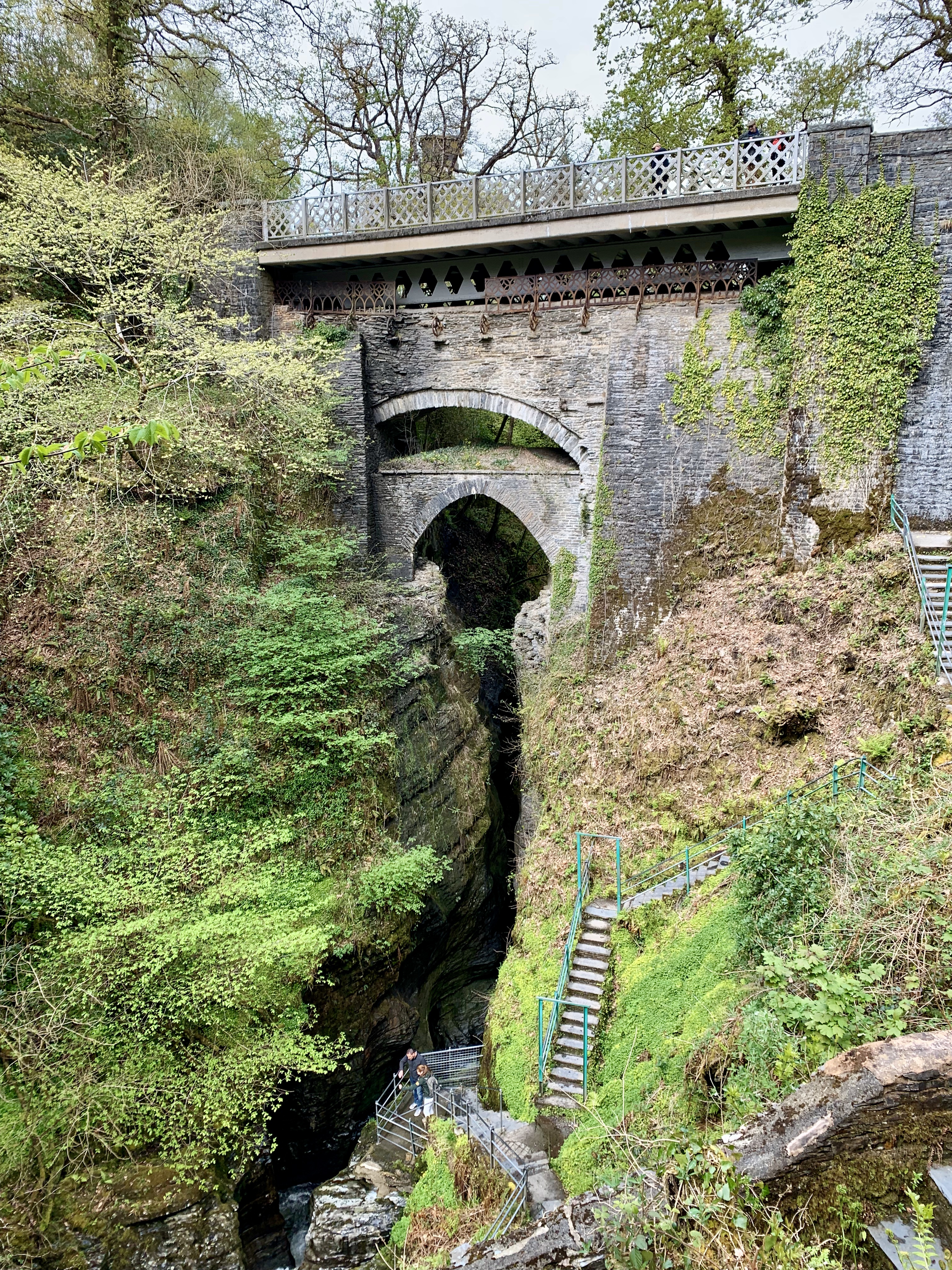
While the legend is likely fictional, the bridge itself is a historical and architectural marvel, with three separate bridges stacked on top of each other, each built during different time periods. The first was probably built by the monks of Strata Florida in medieval times, providing easier access between the properties belonging to the monastery. The second was built in the 18th century by Thomas Edwards, and the third in the 20th century by the Ministry of Transport. All three can be seen stacked one on top of the other.
The village is small and dominated by the Ty Hafod Hotel. Originally built in the early 1700’s as a hunting lodge for the Duke of Newcastle. Over the years, the lodge changed hands several times, and was eventually bought by a local landowner named John Powell in the mid-19th century. Powell was a wealthy man who had made his fortune in the mining industry, and he set about renovating the lodge and turning it into a grand country house. Under Powell’s ownership, Ty Hafod was expanded and modernised. Throughout the early 20th century, Ty Hafod continued to be a popular destination for wealthy travellers. During this time, the house was often rented out as a holiday home or a venue for weddings and events. Many famous people stayed at the house during this time, including the poet Dylan Thomas and the author George Bernard Shaw. After World War II, Ty Hafod fell into disrepair, and it was eventually abandoned. The house remained empty for many years, and it was in danger of falling into ruin. However, in the late 1990s, the house was rescued by a group of local investors who saw its potential as a tourist attraction. Fans of the Welsh detective series Hinterland will recognise the hotel as it was depicted as an abandoned children’s home as a back drop to one of the stories. Aunty and I had a great dinner there after the walk, and it is a place I would recommend if you are in the area.
After passing Ty Hafod, and the Chocolate Shop (you really have to visit here and buy some delicious treats) we quickly left the village and entered the forest, tracking through both coniferous and oak woodlands. The especially dense oak canopy is a sign that the trees here are all roughly the same age. Around the time of the First World War, up to 7,000 tons of trees were felled every week and transported down the valley on the Vale of Rheidol Railway to Aberystwyth before being used as pit props in the coal mines of South Wales. The woodland then must have been even more extensive than today, but the regeneration is continuing.
The amount of rain falling along the western edge of Wales creates a unique wildlife environment and an ecosystem that’s full of lush vegetation, diverse wildlife, and lots of rain hence the name “Western Rain Forest”. The climate in Wales is pretty wet to begin with, but in these forests, it can rain up to 3 meters per year! Everywhere you look, there’s greenery – mosses, ferns, lichens, and all sorts of plants growing on every available surface.
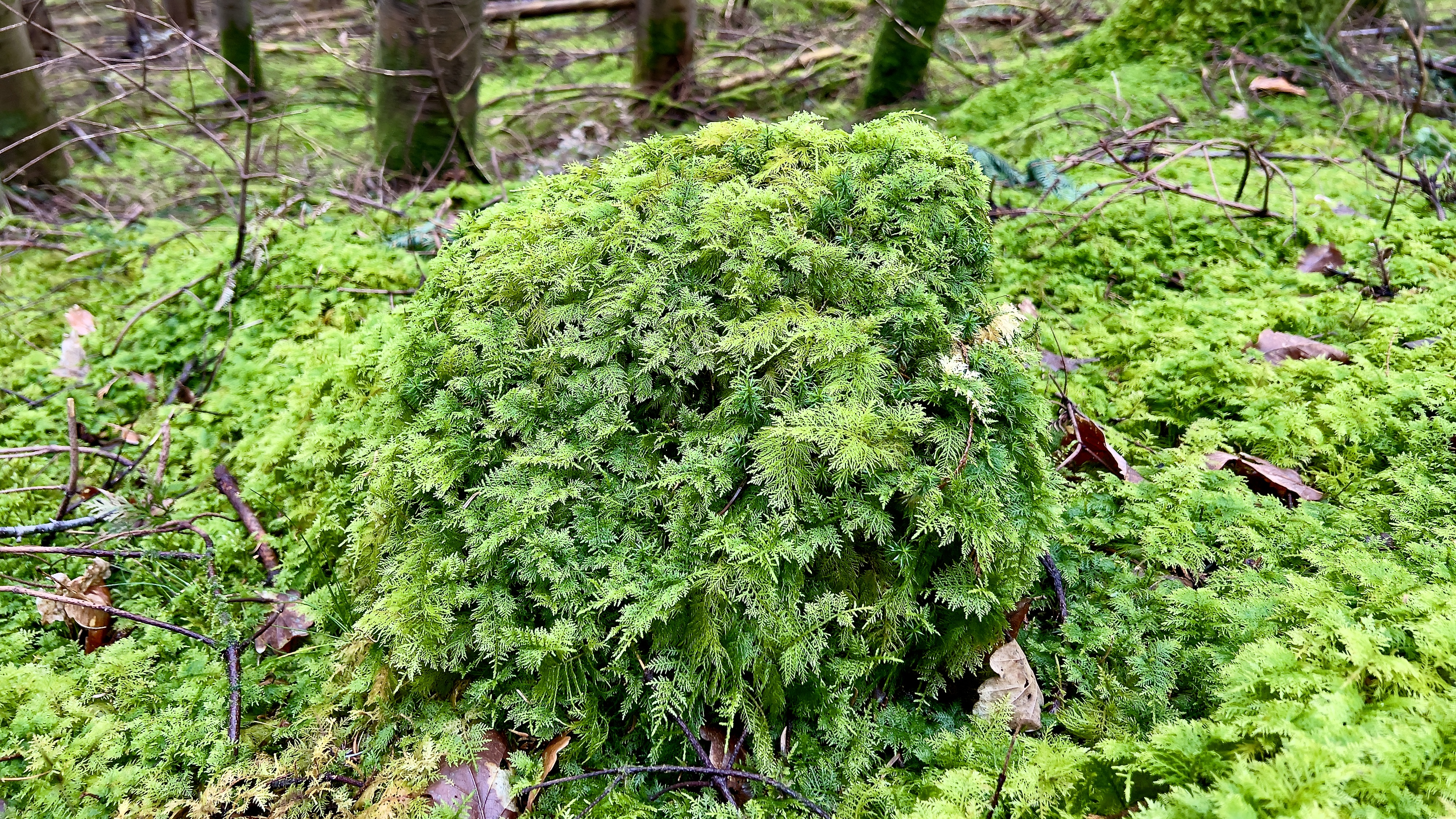
But what really sets the Welsh temperate rain forest apart is the amount of rainfall it receives. My ID skills with mosses is not very good, but I am beginning to recognise some of the more distinctive and common species. One of my favourites is the Common Tamarisk Moss (Thuidium tamariscinum). In places it has created a lush, thick green mat across the forest floor, creating small hummocks as it grows over felled tree trunks (you can read more here). Another common moss I came across was the intriguing named Slender Mouse-tail Moss growing up the tree trunks almost like green velvet trousers.
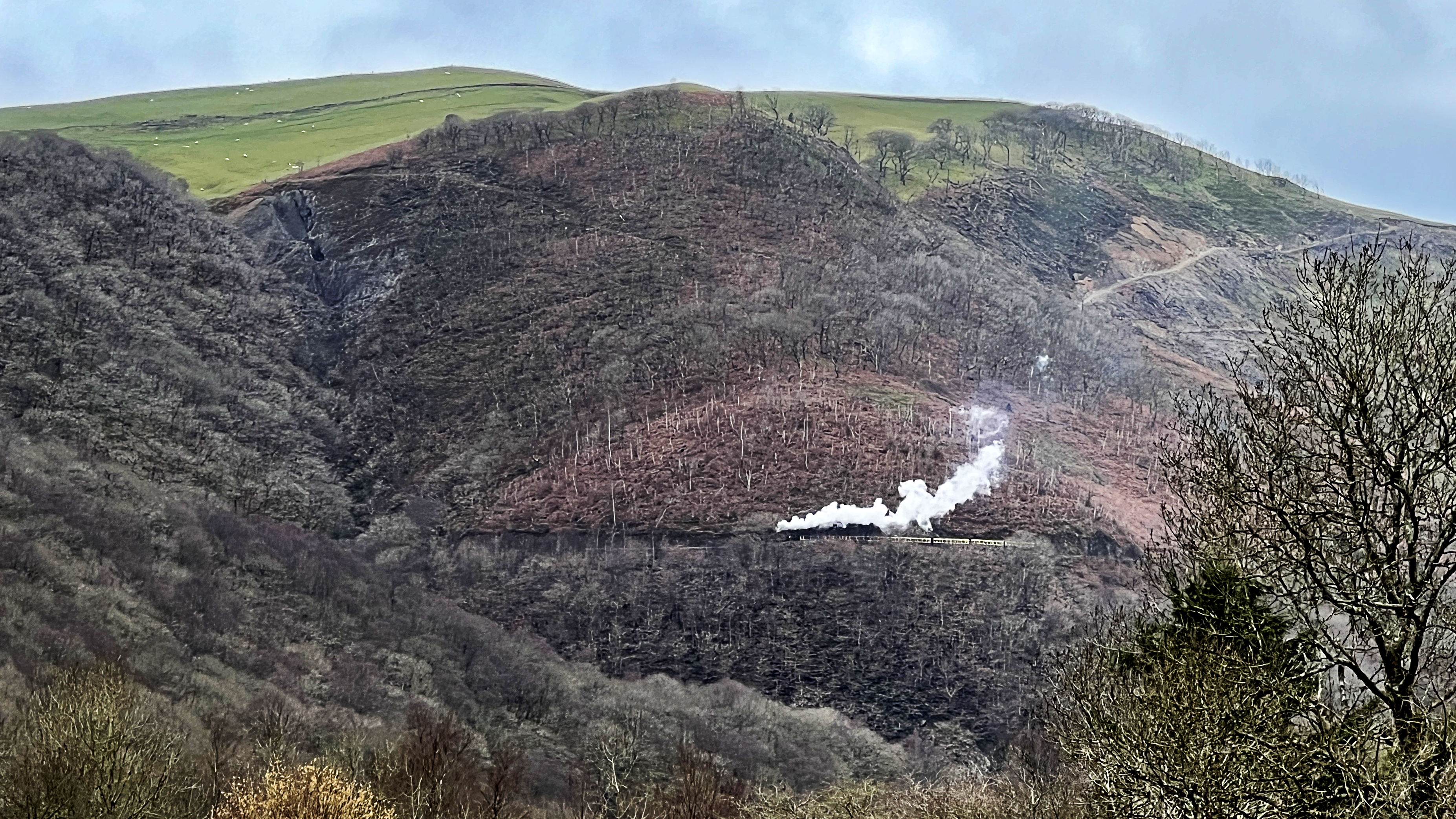
As we descended deeper down the steep valley we watched the first train of the season steaming along the track from Aberystwyth to Pontarfynach. The narrow gauge railway was built in 1902 to transport lead and zinc ore from the mines in the Rheidol Valley to the coast at Aberystwyth. The railway was originally owned by the lead mining company and was built to a gauge of 1ft 11¾in (603 mm). Narrow gauge railways were a cheaper and quicker option to build in the narrow steep valleys of Wales. Unusually for a narrow gauge railway in Wales it was taken over in 1912 by the Great Western Railway. Today it’s a popular tourist attraction and well worth a ride.. In 1904 the line was extended to Pontarfynach in 1904, and the railway became known for its scenic route through the beautiful Rheidol Valley. However, the decline of the mining industry led to a decrease in traffic, and the line was closed in 1968. Fortunately, a group of volunteers formed the Rheidol Railway Preservation Society and began the task of restoring the railway as a tourist attraction. The first train ran on the newly restored line in 1971, and since then, the railway has gone from strength to strength.
This beautiful valley is known today for its stunning landscapes and scenic railway, but it also has a rich history of mining. Today the valley hides it’s industrial past requiring you to look closely, but the signs are there. The area was first mined for lead and silver in the 18th century, but it wasn’t until the mid-19th century that things really took off. That’s when the Cwm Rheidol Mining Company was founded, and they started digging for copper.

The discovery of lead and zinc in the area dates back to the 18th century, but it wasn’t until the mid-19th century that the mine began to be actively worked. In 1853, a group of investors formed the Cwm Rheidol Mining Company and started to develop the site. The steep walls of the valley allowed easy access to the valuable mineral deposits enabling drift mines rather than the need to sink deep shafts into the hillsides. Although not easily visible today the company constructed a number of buildings, including a crushing plant and smelter, and laid a tramway to transport ore from the mine to the processing facilities.
Over the next few decades, the mine underwent several periods of expansion and contraction, as the demand for lead and zinc fluctuated. During its peak in the late 19th century, the mine employed over 150 men and produced over 2,000 tons of lead and zinc ore per year. In 1900, the mine was sold to the Rio Tinto Company, which was already a major player in the global mining industry. Under Rio Tinto’s ownership, the mine was modernised and new equipment was installed, including a compressor for drilling and an aerial ropeway to transport ore from the mine to the processing plant. The company also constructed a new village for the mine’s workers, complete with a school, chapel, and recreational facilities.
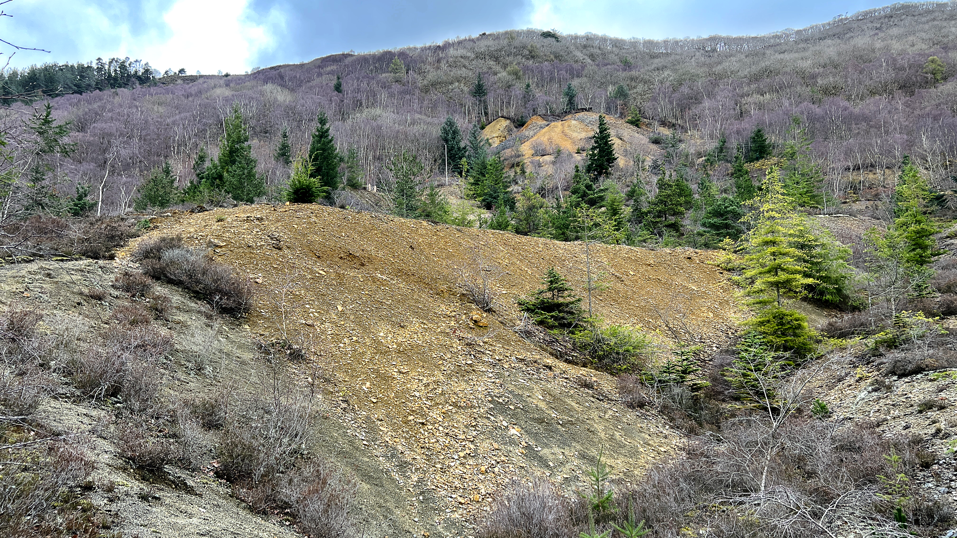
However, the mine’s fortunes began to decline in the early 20th century, as the demand for lead and zinc decreased and the cost of production increased. The outbreak of World War I provided a brief reprieve, as the demand for metal surged, but after the war ended, the mine struggled to remain profitable. Eventually, in 1921, the mine was closed, and most of the equipment was sold or scrapped. The site was abandoned, and over the years, the buildings and infrastructure began to deteriorate. Today, little remains of the mine’s above-ground structures, although the tramway and some of the tunnels can still be seen in the Rheidol Valley.
Today the closed mines continue to have an impact of the valley. One of the main concerns is the discharge of heavy metals and acidic water into the Afon Rheidol, which can have a devastating effect on aquatic life. One of the most significant efforts to reduce this pollution was the construction of a water treatment plant in the 1990s. This plant was designed to treat the acidic mine water before it was released into the river, neutralising the pH levels and removing heavy metals. This has helped to significantly reduce the impact of the mines on the river and the surrounding ecosystem. If you wish you can read more here about the efforts to reduce contamination of the river down stream.
After passing the remains of the mine we started to climb up a number of lung busting but thankfully short ascents back up the side of the valley, though old woodland and a mixture of plantations. The path eventually brought us to the narrow Parson’s Bridge spanning the deep and narrow gorge created by the Avon Rheidol. The bridge is reputedly so-named because it provided a short-cut for the parson walking from the parish churches on the west side of the gorge to the little church of Ysbyty Cynfyn, east of the Rheidol Gorge. Without this it would have been a long walk south or north to get from one church to the other.
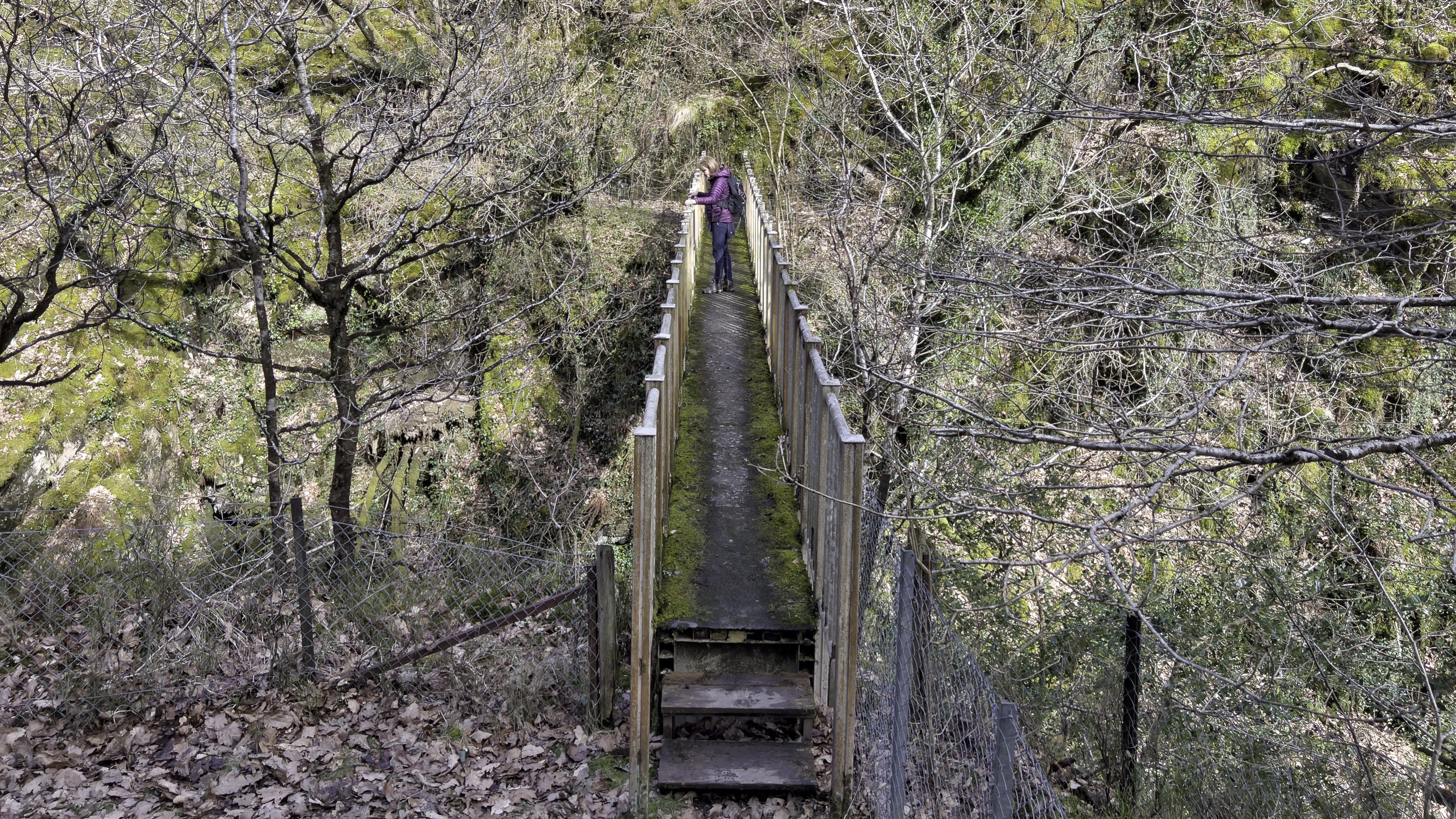
Over the years the bridge has been replaced many times, and up until 1951 the bridge was a single plank hung from the sides of the gorge by chains and sixpence a day danger money was paid to the man who maintained it. Over the years there have been a number of bridges with the current bridge is much more permanent and affords a view down the deep and narrow gorge to the dark peaty waters rushing past below. Just visible through the trees upstream are the remains of the disused Temple Mine, another of one of the lead mines which were operational until the early 1900’s.
Higher up the valley In the 1920s, the Rheidol Hydroelectric Power Station was constructed in the valley. The power station was built to harness the power of the River Rheidol, which flows through the valley, to generate electricity. The construction of the power station involved the construction of a dam across the river, which created a reservoir that is still in use today. But that will have to wait for another day.
After crossing Parson’s Bridge we are confronted with another short lung busting climb through the ancient oak woods before arriving at the tiny hamlet of Ysbyty Cynfyn. Today there is nothing much to see of this hammer except for a couple of farms and a small grey uniform church. However, this small area has a long and complicated history. The present church at Ysbyty Cynfyn was rebuilt in 1827, but there was a church here before this time with the stone reused to build the current building.
The original church was not a parish church during the medieval period, but was a chapel of ease to Llanbadarn Fawr in the Deanery of Ultra-Aeron, serving the parish of Llanbadarn y Creuddyn. Before it was that the church was used as a chapel-of-ease and may have been a possession of the Knights Hospitaller, or may have been associated with Strata Florida Abbey. If the Knights Hospitaller were here this might give an indication to the origin of the name, Ysbyty means hospital or hospice . The church has certainly been at the centre of the local community and was reputedly once used for holding fairs and for rough activities, such as cock fighting and an early, unruly form of ball game. In the nineteenth century, a yearly athletics contest would be held within the church. The benches would be removed and the church would be open all night, with parishioners competing at skills such as wrestling and ‘casting of the barre’. The main spectators were, reportedly young women and former champions. Today is very much quieter, but has it has a reminder of more rumbustious times.

There are hints that the place has been an important site for the community for thousands of years. There are several huge upright stones in the circular graveyard, which hint at an early and even pre-Christian past. It has been suggested that the stones are the remnants of a stone circle, but this is disputed and has yet to be proven. However, although now incorporated into the wall of the circular graveyard the stones are placed in a pattern that is reminiscent of stone circles I’ve seen in the Welsh uplands. But it would be fantastic to imaging that this area has been used for ceremonial activity and worship of thousands of years if they were once erected all those years ago.
From the same womb the same day we came,
From the same breasts we suckled,
In the same grave we lie together,
On the same day we’ll rise again.
Inscription on the gravestones
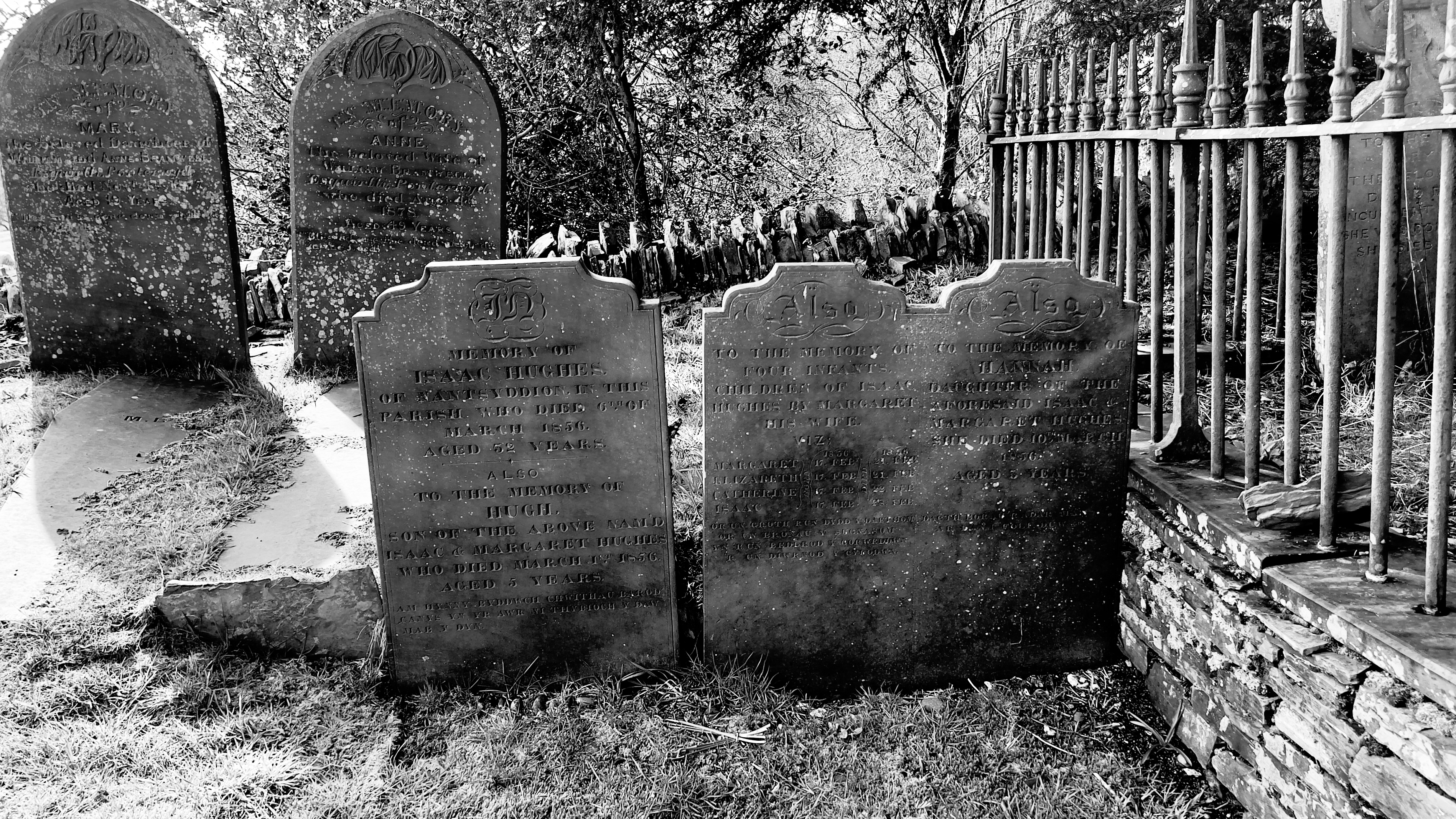
In a corner of the grave yard there are three small grave stones close together. The first recorded quadruplet babies born in Wales were buried here in 1856. The grave, with its typical white quartz cross, is a reminder of the awful hazards to life from diseases such as typhoid , before antibiotics, and the tragedies it brought with it. The quads were born on February 17, 1856, to parents Isaac and Margaret Hughes in Nant Syddion, near Ysbyty Cynfyn. The Hughes family already had two children, Hugh and Hannah, before the quadruplets’ birth. The quadruplets were named Margaret, Elizabeth, Catherine, and Isaac. Tragically, within a month of their birth, an illness, likely typhoid or influenza, broke out in the cottage. The quadruplets, their brother, sister, and father all died, leaving only their mother, Margaret, alive. The Hughes family’s former home, Nant Syddion, is now a bothy, a basic shelter, left unlocked for people to stay in. It’s located in the Cambrian Mountains, 15 miles from Aberystwyth. The story of the Nant Syddion quadruplets is well-known in the region and has become a part of local folklore. Some hikers have even suggested that the bothy is haunted. You can watch a YouTube video of the bothy here.
After that sobering image of tragedy we walked the short distance back to our caravan. In all this 8 mile walk took in ancient and modern forests, pristine areas of natural beauty, old mine workings, river gorges, historical bridges and life tragedy. What more could you want in a day out? But there was one more thing we needed to do and that was visit the Chocolate Factory for a supply of Easter eggs. As we walked in we were instantly surrounded by the aroma of chocolate, and were able to watch through the back wall as Sara Bunton was making the next batch of chocolate. Sarah Bunton was inspired to start creating her own artisan chocolates in 2008 when she was looking for a chocolate train mould on the internet and came across chocolate-making courses. At the time, her parents had a cafe and gift shop opposite the Vale of Rheidol Railway Station at Devil’s Bridge, and she started making her chocolate creations from above the cafe I have to admit mine didn’t last long. Sara now exports her award winning creations worldwide. Go ahead and check her out and make an order. My small supply didn’t last long and I need more!
