
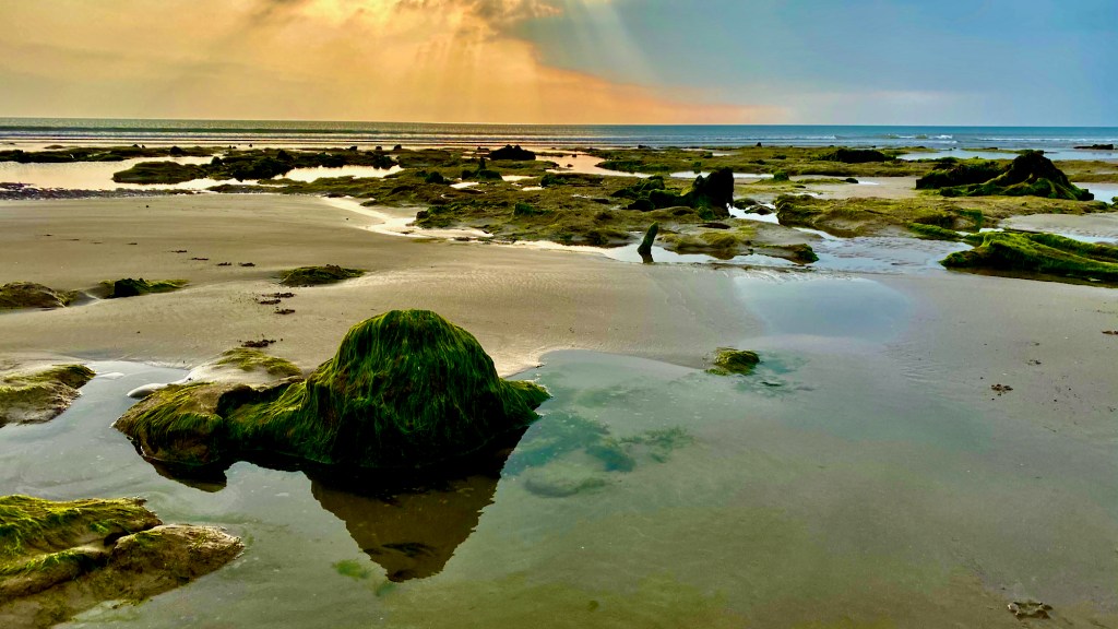
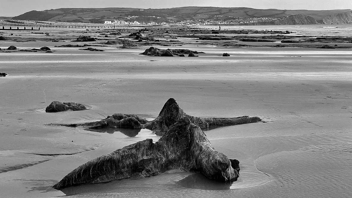
A visit to the beach in Wales will always bring up a surprise, usually it’s the view, the opportunity to relax, to feel the scratchy rasping sensation as you push your toes into the sand. Maybe even get wet in the cold water and delight as the waves crash around you. What you don’t expect is to come across an ancient 5000 year old forest, stretching out before you like a scene from some disaster movie. OK, maybe my imagination is running away with me, but being cooped up for 6 months due to the COVID-19 pandemic can do things to man’s brain. There are no leaves, no birds singing in the branches. But the stumps are, or rather were, defiantly the remains of trees, and you can see how the roots once held them firming to the ground. I’ve known about the submerged forest here for years. After all I was born and brought up just 8 miles north of here at Tywyn, and we had our own mini forest on the beach among old peat cuttings, though nothing like this. But I’ve never visited. In fact there was no reason to visit Borth, it was out of the way to anywhere we needed to travel. Even among the locals and those in the know the extent of the forest wasn’t really appreciated until storms washed away the sand and exposed large areas previously never seen. It was only then that things started to get really interesting. Buried ancient forests appear all round the coast of the UK, including Whitesands and Lydstep, and archaeologists have been exploring our ancient past as a result.
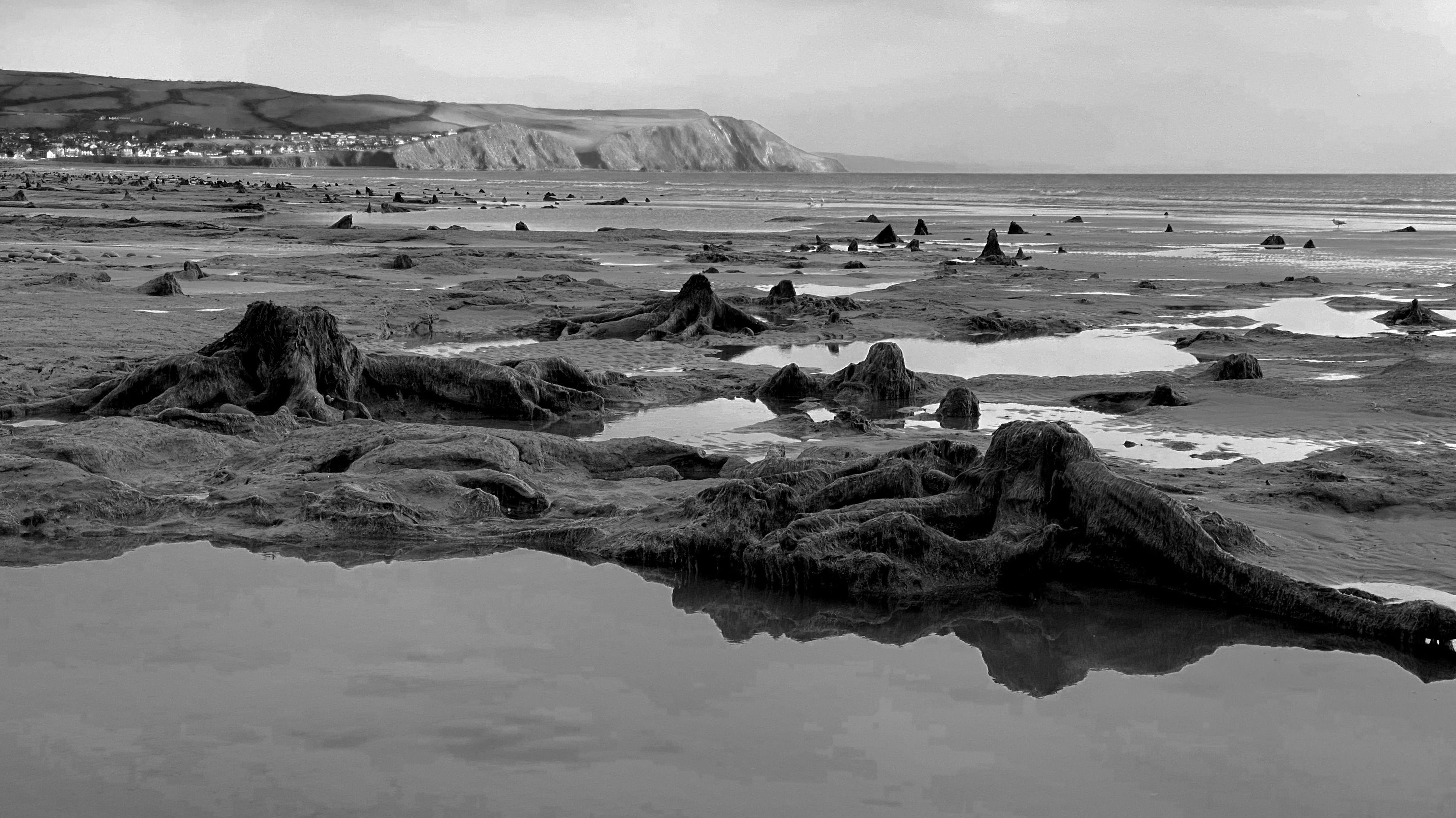
For years locals and beach combers had been finding the occasional interesting artefacts, but following a survey undertaken in 1985 by University of Lampeter the real extent of the finds were appreciated. The survey and analysis of finds suggest that the forest was flourishing between 5,000 and 4,500 years ago (technically I should be using the annotation BP – Before Present, but that seems to be rather formal). But gradually the the area became water logged by 4,000 BP, but oaks were still growing until 3,100 BP at the southern end. The survey found Mesolithic remains including flints, antler trolls and a partial Auroch skeleton. Then storms in the January and March of 2010 washed away sand and exposed a much larger area of forest to the north of the town, followed again by further exposure during the winter of 2011-2012. This revealed human and animal footprints fossilized in the now hardened peat surface, a line of post holes and scatters of burnt stone. But that was all, further storms in January 2014 exposed a wattle walkway and associated posts, dated from around 4,000-3,100 BP. What a find ! Walkways have been found in a number of wetland areas from the Mesolithic to Bronze Age periods in the UK and have been associated with a number of functions from safe passage to ritual. Mind you after years of watch Time Team, any unexplained activity seems to be ascribed to ‘ritual’ by archaeologists.
We has arrived on the beach to see the forest towards late afternoon, partly because we’d been walking all day, but also because it was low tide. There is. No use looking for a submerged forest when the tide is in. Even though there were quite a few popped around it was still a slightly eery experience. So much so it is easy to understand how people from a less cynical and scientific age developed stories to explain what they were confronted with. And, yes you guessed it! There happens to be a very famous Welsh story that all school kids know that seeks to explain the presence of the tree stumps here and other areas along the west coast and northwards. So settle down and we’ll learn of the drowned land of Cantre’r Gwaelod.
A long time ago, in the 6th century if my reckoning is right, Cantre’r Gwaelod was a rich and fertile land extending more than 20 miles west of the current shoreline. Gwyddno Garanhir (Longshanks) ruled this land as part of his wider kingdom of Merionydd. So fertile was Cantre’r Gwaelod that it was claimed that an acre here was the equivalent of 4 acres anywhere else. But like many areas close to the sea it had to be protected, and depended upon a dyke to keep the sea at bay. The dyke had sluice gates that were opened at low tide to drain the water from the land, and closed as the tide returned. One of Gwyddno’s lieutenants, Seithennin, was entrusted with maintain the watch and to supervise the closing of the agues when necessary.
One night a storm blew up on a spring tide, but unfortunately the King had trusted the wrong man. Seithennin was a heavy drinker, and liked a party (don’t we all?). And this night was no exception. Some say he fell asleep due to too much wine or that he was too busy having fun to notice the storm and to shut the sluices. Driven by the rising tide and storm the sea rushed in, flooding Cantre’r Gwaelod, drowning over 16 villages. The King and some of his court managed to escape by running to safety along Sarn Cynfelin. Gwyddno Garahir was then reduced to a poorer existence int eh mountainous landscape of Merionydd.
There is another version of the story, and it is this one that is told in the Black Book of Carmarthen. Named after the colour of its binding, the Black Book was written in 1250, and contained poems and much older material relating to events that had take place centuries earlier, including a poem about Cantre’r Gwaelod called Boddi Maes Gwyddno, The Drowning of the Land of Gwyddno. All these stories are now gather together with other early tales in the Mabinogion, and a highly recommended read. There is a neat translation of the poem here http://www.cantrer.pale.org/pages/poem/.
This second version is a more bawdy story, maintains that Seithennin was a visiting local King, who, at the time of the storm, was intent on a little bit of slap and tickle with Mererid one of the local beauties. Mererid was responsible that night for ensuring the slice gates were to be closed as the tide was rising. The party continued in full swing and everyone was distracted during the feast celebrating Seithennin’s visit to Gwyddno’s court. Seithennin was a little too successful in his wooing of Mererid, and the gates were not closed, resulting in disaster.
Whichever version of the story you chose it is said that if you listen closely on a calm day it is possible to hear the bells of Cantre’r Gwaelod ring out in mournful song for the lost land. The most likely place you can hear this lament to disaster is in Aberdyfi, just across the estuary and the well-known song ‘The Bells of Aberdyfi’ became popular during the 18th Century in the music halls. We learnt it a school and sang it at concerts, though I have to add that this was in the 1960s not the 1860s!
But next question…is any of this true? Well almost certainly not. There are stories from all around the world of drowned lands, and maybe in some cases there were local inundations, but here the story of Cantre’r Gwaelod is an attempt maybe to untangle the mysterious and unexplained features of the landscape. There may be a folk memory based on the slow increase in sea levels, when the water encroaches slowly over rate centuries as the sea levels rose following the end of the last glaciation, but this is based again on myth surely. But there are other features of the landscape on the coast that lend themselves to the story. At a number of places along the coast there are long lines of boulders reaching out into the sea, supposedly the remains of the protective banks not destroyed by the storm.
Just south of Borth is Sarn Gynfelin, a long thin bank of boulders reaching out over a mile into Cardigan Bay, in places only 9 feet below the water surface. After a 1.2 miles there is a shallow channel and Sarn Wallog, another bank, continues further out to sea. These have been taken as proof that Cantre’r Gwaelod existed. However, the more prosaic explanation for these banks of boulders agin lays with climate change. They were created by glaciers during the last ice age. As the glaciers progressed down into what is now Cardigan Bay (of course it wasn’t a bay then) large rocks and boulders there deposited on the valley floor. I like science, but it can take the mystery and romance out of the landscape sometimes. So there you have it, no drowned cities, no amorous kings and no lost lands. Just a gradual and continuing sea level rise over thousands of years after the melting of the glaciers, but maybe some folk memory of what was once there, handed down over countless generations.

Leave a comment