
New Quay is defined as the mid point of the Wales Coastal Path so when we reached here last year it was with some sense of achievement. Now we can concentrate on attempting the rest of the path. We started walking towards Llanon on a chilly and blustery August bank holiday weekend after a week of storms, but despite that the weather forecasters all promised a warm day with sunny periods. I’m not going to claim they lied, but it wasn’t warm, there was little sun, the wind was cold and yes it rained at one point.

This section of the Ceredigion coast is as rugged as the rest, but the geology changes and the high rolling cliffs give way to low expanses of raised beaches with small villages set back from the coast. The walking is easier, and the small sandy bays give way to boulder strewn shores backed either by glacial clay or mudstone and sandstone cliffs. It’s still beautiful if a little less dramatic than Pembrokeshire and southern Ceredigion.
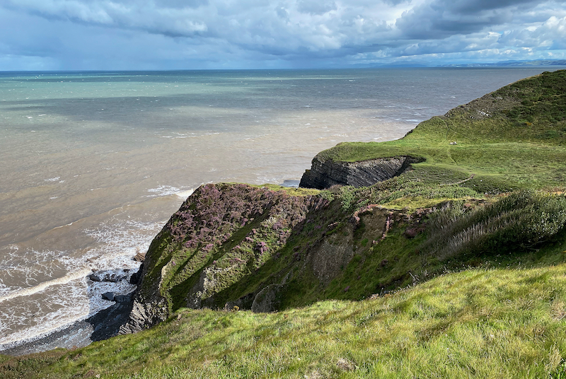
Our first plan was to walk along the beach from New Quay to Llanina, but the tide was in and so we had to climb up the steep hill out of the village and then back down to the beach again. This was the last time in almost 10 miles we were able to reach a beach again. But there were some great places to marvel at. After leaving Cei Bach we were climbing again to the tops of the sea cliffs with some great views over Craig Du. All along here the relatively soft cliffs have been attacked relentlessly by the sea over the years and have created a number of hanging valleys where the the Afon Drywi rushes over the cliffs in loud rumbling water falls. The walls of the cliff face give a great view of the different layers of the sandstone first laid down in the Silurian period, approximately between 433 to 444 years ago. At this time Wales was under a shallow sea.


One of the vagaries of coastal walking is that you sometimes have been walking for hours and each time when you look back the views are different. It gives you a sense of achievement, of having ‘got’ somewhere as you cover the distance. There are other times though, that whenever you look back the view remains the same. It was like this today, having started from New Quay, which is situated on a headland jutting out into Cardigan Bay, was always in sight. Everytime we looked back it was still there! A little smaller, but still there non the less.
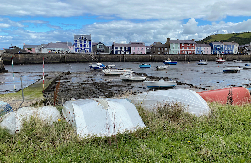
It was so windy and cold on the cliffs our first stop was Aberaeron, a beautiful town surrounding a small harbour. Small Welsh are not known for being planned, and often appear as haphazard developments. Aberaeron however, was laid out in the early 19th century, in a period of smart British architecture. It is now a popular and busy place during the tourist season, but was once an important port and centre for ship building.
This being August Bank Holiday, and the last real opportunity after the pandemic before schools reopen, the place was heaving with visitors. Aunty wouldn’t let me anywhere near the ice cream, but if you are here it’s on the Welsh 100 List to have a honey ice cream.
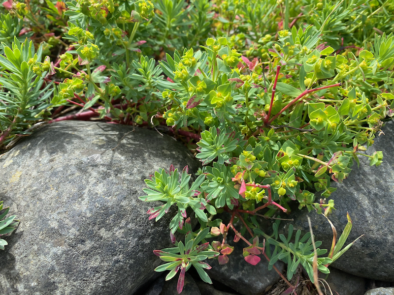
So after a quick lunch (and no ice cream……..) huddled behind the breakwater to hide from the wind we continued along to path following the long shingle bank above the boulder shore. It was along here that I came across a new plant I’d not seen before, Portland Spurge – Euphorbia portlandica. A dainty and delicate looking euphorbia associated with the shoreline. It’s always satisfying coming across a new plant – well I do have two live up to my reputation as a Geek.
The remainder of the walk was now flat and along the shingle banks and field edges just above the beaches to Aberarth, now a small quiet village, but it was once a busy and important sea port long the western coast. However, this declined when the harbour was built along the coast in Aberaeron. In the 12th century the Cistercian monks imported Bath Stone from Bristol for the building of the abbey at Strata Florida, and maintained a presence in the area up to the Dissolution. The Abbey amassed fertile land all around the area donated by Welsh princes and later by Norman lords, all hoping that the prays said by the monks would dissolve them of their sins committed during some of their less savoury antics. Never wishing to miss an opportunity the monks built fish traps or ‘goredi’ to catch salmon, sprats and mullet when the tide went out. I had a look as we were tramping along the path between Aberaeron and Aberarth but either I missed them or the tide wasn’t out far enough. Most likely explanation though is that I missed them, as they look to me to be quite extensive, Cofelin ( click here)has some aerial photos, and they look to be fairly clear and prominent. Aberarth is yet another village we’ve driven through many time but never stopped, there didn’t seem to any point other than to visit family living on the hill. But the path takes you through the old part of the village.


If Aberaeron was an urban planner dream in the 19th century, then Aberarth is the opposite. The tiny narrow streets take you past small cottages that jostle each other for space, facing different directions and built to fit the space available.

12 miles after starting in New Quay we reached Llanon – sometimes spelt as Llan-non. This small village set back from the shore by some way takes its name from the St Non, St David’s mother. Tradition has it that St David was brought up in Llanon, we’ll have to take that on faith as there weren’t any visitors books to sign in the 6th century. The village took on it’s major development in the 18th and 19th centuries funded by the farming and seafaring industries. I’m not sure where the shipbuilding took place, but I assume it was on the shoreline below the village, and maybe my perception of shipbuilding then is wrong, and nothing like the large industrial yards with dry docks today. But it was certainly a major employer, with 130 men working on the ships in 1861 out of a population of 1300. Today there is nothing to see of this industry, and the village straddles the busy A487 road between Aberystwyth and Aberaeron.
It was one of Aunties longest walks today, with a total and a real sense of achievement to finish 12 miles further along the coast and getting closer to where I grew up.

Leave a comment